‘Aerial photogrammetry with drones’ Workshop

Share

The workshop “Aerial photogrammetry surveys with drones” was held at Tirana’s National Museum on Friday, 13th of March 2015.

Antigonea,  © photo: GeoInformatiX&DroneSense-Univ. Macerata

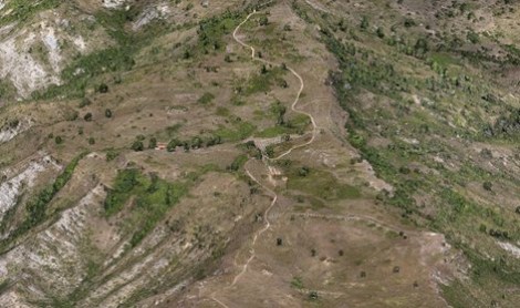
Antigonea: dense cloud snapshot from 3D Model
© photo: GeoInformatiX&DroneSense-Univ. Macerata

It presented examples of aerial photogrammetry surveys conducted by means of drones in the Albanian Drino Valley, Valona Region, in the Hellenistic sites of Hadrianopolis, Jergucat, Frashtan and Antigonea. The surveys were carried out in the framework of the project ReBeD of Macerata’s University  – organiser of the workshop together with the Italian Institute of Culture – for the documentation and promotion of the Drino valley’s cultural heritage.

The frames were elaborated with the Structure from Motion (SfM) method in order to obtain high-resolution 3D models.

Hereafter the workshop programme:


Coordinated by: Roberto Perna


9.30  – Greetings


  • M. Kumbaro
    (Ministry of Culture)
  • S.E.M. Gaiani
    (Ambassador of Italy)
  • A. Frisenna
    (Head of the Italian Institutes of Culture in Tirana)
  • C. Pesaresi
    (Adriatic Project, Marche Region)
  • L. Perzhita
    (Head of the Albanian Archaeological Institute)


10.30 – Interventions


  • R. Perna
    (University of Macerata)
  • D. Condi
    (Head of the Albanian Archaeological Institute)
  • A. Antinori
    (Geoinformatix, University of Macerata)
  • A. Kasi, M. Kocollari
    (Regional Management Gjirokaster’s Cultural Monument)
  • M. Sargolini, C. Gamberoni, R. Caprodossi (Terrepuntoit, University of Camerino)


Download the programme in Italian language (PDF)

For more information visit GeoInformatiX of Alberto Antinori


Leave a Reply


Related Articles

Meeting INCULTUM pilot in Greece, in the valley of Aoos river
A meeting was organized between INCULTUM partners Promoter, and The High Mountains cooperative to review the work done so far for the participative action to enhance the Aoos river's valley and unlock its tourism potential, in the context of INCULTUM Pilot 7 Aoos the shared river. Aoos Valley belongs to Konitsa’s municipality, a mountainous municipality that hosts one of the most sparsely populated areas in Greece. Konitsa is the main town of the area and the capital of the municipality s...
Travelling to Albania to INCULTUM pilot in Upper Vjosa Valley
A meeting was organized between INCULTUM partners Promoter, CeRPHAAL and the Municipality of Përmet to visit the sites of the INCULTUM Pilot 8 Vjosa the shared river. The Pilot aims to support touristic development of the area, by exploring the ‘hidden’ potential of cultural heritage and landscape assets of the Upper Vjosa Valley, and also attempting to balance experiences on both Albanian and Greek territories who share the Vjosa/Aoos river. The pilot develops by focusing on the t...
Reconstruction of Vlach’s dwelling ‘kalive’ in Upper Vjosa valley (Albania)
text and images by Egla Serjani, CeRPHAAL During the second half of July 2022, CeRPHAAL team was engaged in the reconstruction of a Vlach's historical dwelling, the 'kalive'. The Vlachs, which are known to themselves as Arāmān/Rāmān, are an ethnolinguistic group that have historically inhabited swathes of the Balkans territory. They are distinguished by their language, which is a dialect derived from Latin, and by their way of living, based primarily on long-distance seasonal pastoral transhu...
Hicking trail on the historical route of transhumance in Vjosa valley
text and images by Egla Serjani, CeRPHAAL During end of June to early July 2022, members of CeRPHAAL, along with volunteers from the town of Përmet in the Upper Vjosa valley, walked along and recorded one of the historical routes, which was followed by pastoral transhumant Vlach communities during their yearly seasonal movement from lowland winter pastures in Ionian coast to upland summer pastures in Mt Gramoz. The hiking trial includes a section of the route that passes from Dhëmbel Mt p...