

text and images courtesy of Elena Correa Jiménez (University of Granada).
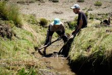
Another participative activity was organised in the framework of INCULTUM Pilot by the Biocultural Archaeology Laboratory (MEMOLab), coordinated by Professor Dr. José María Martín Civantos, from the Department of Medieval History and CCTTHH of the University of Granada. The fieldwork of digitisation of irrigation ditch networks and location of elements intended to the creation of cultural trails: in Pórtugos, where we will make a route through several irrigation ditches, and also in Castril, in the Vega de Tubos, next to the river Castril.
For this work, we counted on the collaboration of the town councils and the irrigation communities of the municipalities.


Information about Castril: Castril is located in the northeast of the province of Granada, on the border with the province of Jaén, nestled in the group of mountain ranges that make up the pre-betic domain of the Betic mountain ranges, characterised by limestone lithology from continental and marine sediments of the Mesozoic period. The municipality coincides with the upper catchment area of the River Castril. The source of the river is a plentiful spring, located in the area of Cortijo del Nacimiento, with the water gushing forcefully through open fractures in the limestone. At present, the total irrigable surface area of the municipality of Castril corresponds to 485 hectares, 01 area and 63 centimetres; in addition, the flour mills of Casildo, de la Cerrada, de los Correas, del Reto (in ruins), de la Virgen and del Chorro, which make use of the motive power of its waters, can be identified.The areas where we are carrying out the mapping work are the Vega de Tubos and the river Castril.
The Vega de Tubos has its source in the spring of the same name, located about 2.5 km NE of Castril, near the tail end of the El Portillo reservoir, at an altitude of 1080 m. It is located in the area of the Natural Park of Castril. It is in the Sierra de Castril Natural Park. The source is in the reservoir itself, and very close by there is a low pillar with two spouts. One of them pours water from this spring, and the other, a colder water that comes from the drinking water network of Castril. The reservoir that stores the water from the Los Tubos spring and the surplus from the Juan Ruiz spring, the main discharges from the Sierra Seca aquifer, distributes the water through irrigation ditches used for irrigating the fertile plains. There are three ditches that make use of the water from the Tubos spring.
Firstly, the Alto brachial leaves the pond on its north side, and has a total length of 660 metres, draining, in the middle brachial, also called Brazal de Sobrantes, part of its west side, and has a length of 1.2 kilometres. Finally, the most complex of all, the Third Canal, with a length of 6.3 kilometres, starts on the south side of the Fuente de Tubos. The Castril river rises in the north of the municipality in the area now known as the Sierra de Castril Natural Park, and within it, in the Barranco de las Palomas ravine. It runs southwards, bordering the village’s characteristic rocky outcrop (where the remains of the old Muslim fortress can still be seen today), to continue its course towards the municipality of Cortes de Baza. The presence of water throughout the year has allowed the organisation of an important cultivated area throughout its basin, which is the result of continuous practice since medieval times. For this reason, it is not surprising that a significant amount of one hundred and forty-one fanegas of land is distributed in its vicinity, and that a considerable number of commoners benefit from it.


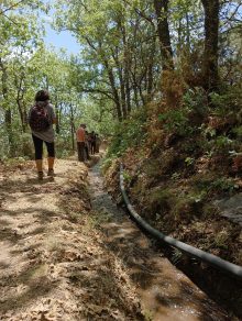
In the case of Pórtugos, a municipality in the province of Granada we have designed a route along two irrigation channels that take the water from the melting snow in the high mountains of the Sierra Nevada to infiltrate it later, thus retaining the water for a longer period of time. During the months of March to June, these ditches divert water from the headwaters of the rivers to infiltrate it into the water-bearing materials in the upper parts of the valleys. The infiltrated water slowly circulates through the surface aquifers and increases the flow of the rivers and springs downstream. In summer, the irrigation ditches are no longer used and another extensive network of irrigation ditches, located at lower altitudes, begins to divert water from the rivers to irrigate the intensive farming areas. The ditches are the Paulo ditch and the El Coto ditch, these take water from the river Jabalí.
The route will cover part of these irrigation ditches and tourists will be able to learn how the irrigation ditches work, as well as walk through the unique spaces created by these channels.
Learn more about INCULTUM Pilot 1 – Altiplano de Granada